Eskom pioneers high-tech airborne laser survey technique
22 November 2000
News
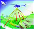
One of Eskom's pioneering technical innovations being showcased at Hannover Expo 2000 is the Airborne Laser Solutions (ALS) technology for conducting high-speed and accurate linear surveys of thousands of kilometres of transmission lines over difficult terrain. ALS technology is able to measure 18 million points per hour and is some 100 000 times faster than conventional surveying methods, according to Eskom. Airborne Laser Solutions (ALS) is an Eskom Enterprises company based in Midrand.
Peter Moir, a manager of Eskom Enterprises, explains that a laser scanner is combined with a camera and mounted on a helicopter. Surveys are done in flight. The digital camera beneath the helicopter is triggered by a computer, which ensures correct spacing of the pictures, and stores them. They are then converted into orthophotos in processing at the home office.
"The technology enabled us to complete a 600 km survey of proposed lines between the Camden and Arnot power stations and Maputo in six days. It would previously have taken a full year."
The survey results are fed into dynamic thermal rating software, which simulates the results of higher power transmission on the lines. This advanced technology helps Eskom save the cost of erecting additional lines by enhancing the carrying capacity of the existing lines.
"Recently, the use of ALS on four existing power lines of 400 kV and 275 kV showed that it was possible to raise the conductor temperature on one of the lines and increase power flow by 50% under certain conditions and increase power flow on the other three. This resulted in savings of R22m."
Moir says that Eskom began work on the ALS concept some five years ago and then discovered that a Canadian company had done similar development work. Instead of re-inventing the wheel, Eskom purchased the main component in the system and customised the design to suit its needs. The complete ALS system is made up of a global positioning system and a laser distance measurement system which uses time and speed of light to calculate distance. Using raw images with an exact centre point, the digital camera rectifies and converts the image into an orthophoto.
For further information contact Peter Moir, Airborne Laser Solutions, (011) 315 8660.
The laser mapping system consists of a sensor head housing an infrared laser, inertial measurement system, receiver optics and electronics and a control rack. During survey the infrared laser emits narrow optical pulses which a scanning mirror directs perpendicularly to the flight path. The scanning motion provides coverage to either side of the flight direction, over an operator-specified swath angle, while the forward motion of the aircraft provides coverage in the direction of flight. The optical pulses are reflected back from the ground, collected by the receiver optics and detected by the receiver electronics. The time taken for the pulse to travel to and reflect back from the ground is accurately measured and the range from the sensor to the ground can be calculated
Further reading:
From the editor's desk: The art of measuring the truth
Technews Publishing
Editor's Choice News
All electronic measurements are a lie. The trick is making the lie as small as possible.
Read more...
TSE has relocated
News
The Technology Station in Electronics (TSE) has entered a new chapter with its relocation from the CSIR campus to TUT-owned building at Ditsela Place in Hatfield.
Read more...
Innovative MyLegrand app
RS South Africa
News
Legrand SA is set to launch the MyLegrand mobile application, a digital platform designed to strengthen engagement across its professional network.
Read more...
Kulani Energy acquires critical assets from Optipower
News
Kulani Energy preserves engineering, procurement, and construction capability and positions a wholly women-owned firm at the forefront of South Africa’s grid expansion.
Read more...
From Cape Town to Johannesburg
News
Würth Elektronik South Africa has taken a significant step forward with its recent relocation from Cape Town to Johannesburg, marking a new phase of growth and ambition for the company.
Read more...
Lesley Havenga: Building partnerships for Africa’s electronics future
Editor's Choice News
As Würth Electronik expands its footprint across South Africa and the broader sub-Saharan region, Havenga’s blend of manufacturing expertise, supply chain knowledge, and people-centred leadership appears well suited to the task.
Read more...
Tackling e-waste with help from international partners
News
Every year millions of electrical and electronic devices and appliances, including mobile phones and computers, are thrown away and these items are now the fastest growing waste stream in the world.
Read more...
From the editor's desk: Pricing surge reshapes engineering reality
Technews Publishing
News
The recent and continuing surge in memory prices has become more than a supply-chain story confined to global semiconductor markets. We have watched in disbelief as the ASP of memory has risen by over
...
Read more...
Siemens democratises EDA software access
News
This collaboration will provide streamlined access to advanced electronic design automation software for European semiconductor innovation.
Read more...
Components distribution: A promising trend
News
The European electronic components market returned to solid growth in Q1, gaining 16,9%, with broad, but uneven, momentum across the region.
Read more...


 printer friendly version