


According to Google, of the 5465 satellites orbiting the Earth, 154 are primarily used for navigation. Although the latter number might not seem considerable, these innovative orbiting objects enable civilians to access geopositioning information. Thanks to Global Navigation Satellite System (GNSS) receivers, navigation systems provide real-time positioning to vehicles while on the move, along with estimated travel times. In addition, when these receivers are embedded in our phones, we are a few clicks away from accurately determining our whereabouts, whenever we want.
We have come a long way in the thousands of years since the innovation of physical maps based on surveying, triangulation, cartography, and other methods used to understand location. For centuries this was accurate enough for people to find their way when travelling from one point of a city to another, from one city to another within a country, or from one country to another. And now, satellite geopositioning has come to facilitate the experience, enabling users to pinpoint their location accurately and in real time.
An outer space conquest, the Doppler effect, and an “aha moment”
Like many other technological advancements, geolocation technology originated as a byproduct of technology designed for a different purpose. The launch of the first satellite by the Soviet government in 1957, initially intended for radio wave transmission, not only sparked a race to conquer outer space but also led to satellite-based location tracking. Although Russian engineers were the first to put a satellite in orbit, they did not anticipate the potential for location tracking these devices would bring. American engineers realised this use based on studying the motion of an object that emits waves.
The Doppler effect is the scientific principle explaining what happens when objects move while emitting radio signals, such as the sound of a travelling ambulance or police vehicle with its sirens on. As an observer, you may have experienced a sense of disorientation when unsure of the direction from which the sound is coming, whether the vehicle approaches or moves away from you.
This disorientation originates from the change in frequency experienced by your ears (receiver).
The Doppler effect was immortalised in popular culture when Sheldon Cooper, a fictional character from the TV series ‘The Big Bang Theory’, wore a costume inspired by it to attend a costume party.
American engineers initially harnessed this scientific principle – by monitoring the frequency shift of radio signals over time – to calculate a satellite’s position. These were transmitted to the satellite from a ground station on the Earth’s surface. A pivotal breakthrough occurred when Frank T. McClure noticed what could happen when reversing the waves’ travelling direction. This moment of clarity gave rise to the satellite positioning revolution. The satellite then became the wave emitter, thus making it possible to find a receiver’s position on the ground.
McClure’s idea quickly landed in the Johns Hopkins University Applied Physics Laboratory, and in no time, it gave rise to Transit, the first satellite navigation system. The magic number comprising the first satellite constellation was five. That is, by using the data from at least five satellites, they could achieve a reasonable degree of positioning accuracy.
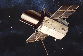
Before GPS, there was the Transit system
Conceived in the 1950s, the Transit navigation satellite system became fully operational in 1964. Aided by a constellation of satellites in Low Earth Orbit (LEO) transmitting radio signals to receivers on ships, aircraft, and other transportation means, it measured the Doppler shift to determine their location. The system was designed for maritime navigation, and provided reasonable positioning and timing information for civilian purposes.
Over the years, although the system underwent several upgrades and improvements to enhance coverage and accuracy in navigation, it had its limitations. Still, the system established the foundation for satellite geolocation technology.
In 1978, the first GPS satellite was launched. Although GPS satellites evolved from what was learned with the Transit system, they operate differently. GPS satellites are Medium Earth Orbit satellites (MEO) that, relying on atomic clocks, broadcast precise timing signals. Receivers on the ground calculate position, considering the time it takes the emitted signals from satellites to reach them. In this case, accuracy increases by the number of satellites working concurrently; what is known as trilateration.
The first vehicle navigation system
In the late 1970s, as engine performance had improved considerably, the Japanese automotive industry turned its attention to electronics technology. The engineer Tagami Katsutoshi shaped the first navigation system integrated into a car. After multiple revisions and using a gyroscope, map films, and helium propulsion, Katsutoshi’s team presented the Honda Electro Gyrocator in 1981. The principle behind it, known as dead reckoning, was intrinsic to the car’s motion. By knowing the departing point, the vehicle’s speed, and the direction taken, it was possible to know the car’s location after a given amount of time.
In 1983, President Ronald Reagan allowed the commercialisation of GPS technology for civilian use. Six years later, Magellan Navigation Inc. launched the first GPS receiver. And another year on, in 1990, the automotive market released the first vehicle with access to satellite geolocation. However, although the system commenced to be in use, it was not until 1993 that it became fully operational through 24 satellites.
A map in your phone
In the early 2000s, geolocation was integrated into another widely-used technology that millions of people use daily: smartphone map applications. The history of map applications commenced with the first digital computer maps. ESRI (Environmental Systems Research Institute) was the pioneering company that made significant developments in this area.
Founded in 1969 by Jack Dangermond, the company’s innovative work laid the foundations of Geographic Information System (GIS) technology. This technology combines satellite imagery, data from users and content providers, and aerial photography.
The Danish brothers Lars and Jens Eilstrup Rasmussen used GIS technology to create Google Maps in 2004. Initially, the service was not intended for smartphones, but the idea gradually took shape over the next three years.
Aerial photography, with its origins in balloon-based and kite photography in the 19th century, became crucial for earth mapping. In 2005, Google acquired Keyhole, a company that supplied aerial photos of the Earth. This acquisition meant a critical step for the foundation of Google Earth.
Over the next two years, engineers devoted their time to bringing Google Maps to light. Finally, by the end of 2007, Apple released the first mobile device with assisted GPS location featuring Google Maps. This marked a significant milestone in the widespread availability of geolocation; from that point onwards, everyone could find their current location by clicking a few times on their phones.
The glimpses of recent historical landmarks mentioned by no means cover all the developments contributing to satellite geolocation and its applications. Nevertheless, they illustrate how the visionary ideas of certain individuals at specific moments have directed satellite geopositioning, setting the stage for creating applications that facilitate navigation in our daily lives.
The contributions of engineers who developed satellite-based geolocation, the first vehicle navigation system, GPS receivers, map applications, and mobile devices with GPS location have collectively propelled geolocation into its current state. While these engineers may have predicted the impacts of their developments, it is unlikely they foresaw the full scope of their contributions.
| Tel: | +27 21 555 8400 |
| Email: | [email protected] |
| www: | www.rfdesign.co.za |
| Articles: | More information and articles about RF Design |


© Technews Publishing (Pty) Ltd | All Rights Reserved
 printer friendly version